Friday, May 28, 2010

Memorial Day Weekend

70% of this weekend is looking great! highs will be in the 80s (70s along lake huron M-25) Saturday. And Pushing 90 in the southern part of the state on Sunday. If you're heading to Northern Michigan it looks great as well with highs in the 80s inland and 70s near lake huron (US-23) on Saturday. Sunday Highs will be in the low to mid 80s. Sunday Afternoon there is a slight chance of a t-storm near the lake huron shoreline with a lake breeze developing. A better chance of t-storms on Monday, some maybe severe with damaging winds as a cold front passes on through.

Wild fire danager is through the roof in Northern Michigan. Be careful!!! Please follow all local burning bans in Northern Michigan!!!!!

Tuesday looks cooler before the heat returns agian for Wednesday and Thursday of next week.

Enjoy the BBQ's :)

Thomas

Monday, May 24, 2010

Summer Pays A Visit

90? you got it over the next few days. Of course like anything there is some red tape.

Here is the surface map.


Warm front has lifted well into Northern Ontraio. Out ahead of it very "hot" air. Infact, temps had no problem reaching the upper 90s in Minnesota Monday Afternoon.


The core of the hot air will take a run at Michigan starting Tuesday and will peak on Wednesday before a cold front that may trigger a t-storm on Thursday moves in. I think will sneak in another 90 or close to 90 degree day on Thursday before storms fire Thursday Afternoon - Will touch on Thursday in a sec.


Tuesday, will have a southeast wind flow. That will keep the Lake Huron, St.Clair and Erie shore lines around 80. Areas inland will reach the upper 80s with sunshine. So thats the red tape I was talkin about earlier.


Wednesday the red tape gets takin away and a southwest wind takes over, that sends the 56 dregee cooled water air into Ontario. Highs across all of Southern Lower MI should have no issues reaching 90. Also, higher dewpoints will be rollin in on Wednesday as well. Dewpoints are a mesurement of how moist the air is. The dewpoint temperatures won't be to bad Monday Night, and Tuesday. So you might be able to get away with out you're AC through Tuesday Night (espeically if you live near the lakes). But Wednesday, the dewpoints go up, and so does the unconfort level. Also Wednesday Night, temps will struggle to drop below 70.


Thursday, we take another run at 90. But a cold front will be knockin on lower Michigans Door.


Right now, its a slim chance of storms. Timing is an issue of the front passage and will have to be ironed out over the next couple of days along with severe weather chances. What this front will do though is drop us about 10 drgrees on Friday.
Friday night and Saturday Morning a backdoor cold front (a front that moves from NE to SW) will move across Lake Huron and into Lower MI. Still a question if it will produce rain. But this is the bad news part of the blog as temps take a tumble for Saturday and Sunday of Memorial Day Weekend. Highs will be in the 70s inland across Lower MI and 60s across Northern MI. Still pretty nice, but a little cool for water fun such as boating and jet sking.
Will have a better up north forecast for the upcoming memorial day weekend on Thursday. Including an update on burning bands.
TK


Thursday, May 20, 2010

Friday Rain

A closed upper level low over Missouri will head towards the great lakes on Friday. Clouds will overspread the area through Friday Morning. There is going to be more clouds than sun Friday. Temps will stuggle to reach the the upper 60s.

Friday will be the last cool day. Temps are back into the 70s Saturday, then its into the 80s and possibly 90s. Next week with dry weather.

Take Care,
Thomas

Tuesday, May 18, 2010

Northern MI Wildfire

A major wildfire has broken out in the Grayling area. So far 3,000 acres have been burned according to 9 & 10 News. On the Visible Satellite shot, you can clearly see the smoke extending from Grayling back west towards Kalkaska.


For those of you who don't know where Grayling is. It's pretty easy to find the wild fire, look at Northern Lower MI. And right in the center of Northern Lower you will see what looks like clouds, but it is smoke from the wild fire. And that is where Grayling MI is located.

This enforces the reminder that burning in Northern MI and the U.P. is totally off limits. With most of the northern part and the U.P. in a moderate and severe drought from lack of rain or snow in the last 6 months.

Thomas

Thursday, May 13, 2010

Thursday Afternoon Wx and Bits

we have a break from the soaking we took Thursday Morning. We have one more round of rain coming. Severe weather is possible, especially south of M-59. An isolated tornado can't be ruled out south of I94. Temps will range from the 40s/50s north to 60s and 70s south of Detroit.

Tuesday, May 11, 2010

Kips and Wx Bits

With the water mixed in, lots of it !

Round one of the water is moving out. Round 2 will be moving in on Thursday.


We have had near 2" of rain in the last couple of days. This model run indicates near 2" of rain on Thursday Morning and Afternoon. NAM model is a little less, but with all the rain we have had over the last couple of days. 2 more inches of rain wouldn't help matters. So come Thursday be on the look out for some localized flooding possibly. Thunder is also in the mix for Thursday Morning and Afternoon. As of right now severe weather looks to stay south of the broader of MI. But and isolated hail producer is possible.
Temps are going to stay cool through the end of the week and into the weekend with highs in the 55-60 range. And lows in the 40s to near 50.
TK

Monday, May 10, 2010

Monday Afternoon Weather Bits


A Severe weather outbreak is expected over KS/MO/TX and OK Monday afternoon and night. A couple strong tornados are possible, especially with in the high risk part of the SPC outlook.


Tuesday Evening

This same storm system will bring very heavy rain once again to lower MI. Severe weather is possible south of lower MI in Indiana and Ohio. No severe weather is not expected in lower MI. but rain and cooler temps are in the forecast for Tuesday.

Saturday, May 8, 2010

Much Needed May Snow

Yep, I just said that above. "Much Needed May Snow"

Snow fell across Upper Michigan and in some of the higher elevations of Northern Lower Michigan. This was much needed snowfall for this region. This was a due to a strong spring storm system that also brought severe storms and windy conditions to the Southern part of MI.


Due to the El-Nino type weather pattern back in Dec, Jan and Feb. Most if not all the storm tracks took a southern route, leaving Northern and Upper Michigan dry and in the cold. For some areas in the North after the Chirstmas Eve and Day Ice Storm that turned into a cold rain, that was the last of the pre-cip for over 3 months for some.


Below is the Drought Monitor, from the Unveristy of Nebraska. As you see, its a moderate drought for areas a long and north of M-32 (Gaylord-Alpena) and in the upper for areas east of Marquette. West of Marquette, it is a severe drought for all of Western Upper Michigan.


Here are some off the snow fall reports from Friday Night.
Upper MI Snowfall Reports
Sindaw MI - 4.6"
Negaunee MI- 3.9"
Alberta MI - 7.6"
Gwinn MI - 3.5"
Ironwood - 4.5"
Iron Mountain - 1.9"
NWS Marquette - 6.6"
Northern Lower MI Snowfall Reports
Atlanta MI - 3.5 "
Gaylord - 2.3"
For the NWS in Marquette, this ended up being the 3rd highest snowfall for the month of May.
TK

Friday, May 7, 2010

Update

Storms are starting to fire along I-69 from Lansing to west of Coldwater. Some of these storms have been capable of producing hail up to Baseball size, these storms look to move into the Detroit Western Suburbs around 6.. Tornado Watch remains in effect until 11

on a side note

After the severe weather moves out tonight and this storm system moves into Ontraio. Winds are really looking to scream tonight after about 10pm. At times winds may gust up to 40mph or slightly higher. The strong winds will stick around through Saturday. A wind advisory will likely be issued starting after Midnight and continuing through most of the day Saturday.

Winter Weather Advisories are in effect for areas north of Gaylord. And believe it or not Winter Storm Warnings are in effect for parts of U.P. 3-7" of snow is possible along with strong winds. Some snowflakes may mix in as far south as I-69.

will contiune to monitor severe weather through 10pm

TK

Tornado Watch

Severe Threat Today


Tornado Watch is in effect for parts of Southern Michigan, the counties shaded in the red are under the watch. I know most of the action looks to be in Indiana and Ohio... But there is a chance for severe storms across all of SE MI with large hail and damaging winds (Espeically South of I-69) The Tornado threat does increase as you head towards OH and IN.


The Next 2 Maps are all with in a 25 mile point


Tornado Threat


Hail Threat


Damaging Wind Threat (Wind over 58mph)


Wednesday, May 5, 2010

Forecast Update...

A severe t-storm watch has been issued for Toledo points south through Wednesday Evening. I think we have about an hour to go with the severe weather. Then we will have a steadier rain for the rest of the evening.

Severe T-Storm Warning Update

Severe T-Storm Warning remains in effect for Wayne County until 430. This storm will remain south of Downtown Detroit, so areas downriver will exprience possibly quarter size hail and damaging winds.

TK

Special Marine Warning

For the boaters, jet skiers and pirates out in Lake St. Clair and the St. Clair River . A Speical Marine Warning is in effect until 4:45pm.

Mesoscale Disccusion


Long story short, Severe T-Storm watch is looking likely for NE Indiana, Northern OH and Possibly Monroe and Lenawee Counties in SE MI

Wednesday Severe Weather


There is a chance of severe t-storms Wednesday Afternoon south of a Port Huron to Adrian line. Time frame for possible severe storms look to be between 2 and 6pm. After 6pm the severe threat will side south into Ohio and Indiana.


Wednesday Morning's sounding shows an inverted V. Which would possibly indicate possible severe wind. Also with the freezing level below 9,000 feet, hail may also be an issue. Tornados look not to be a threat.


Wind Threat


Hail Threat


Tornado Threat


Tuesday, May 4, 2010

Tuesday Forecast


A warm front will be pushing through Tuesday Evening. This may touch off a storm but it is a slim chance. Temps Tuesday afternoon will be in upper 60s to lower 70s.
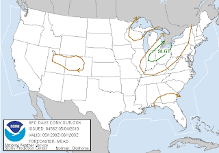


Southeast Lower MI from about Port Huron to Coldwater is under a slight risk Wednesday for severe t-storms. Timing differences though in models may limit severe weather, but I think we do have a short window across this area Wednesday for severe t-storms. Will look better into this chance in the next blog.

Game Day!
Full Force Red!
Kip!

Monday, May 3, 2010

Monday Night Forecast

We will have a shot of showers and thunderstorms tonight across the area as a trough moves through lower MI. A Severe T-Storm Watch was posted for IN/IL as of this Blog. I think Severe Weather though will be slim to none across Lower MI. Lows Monday Night will be in the mid 50s.


Tuesday a warm front will push through the state. Thinking right now that this warm front is going through dry. But the atmosphere becomes slightly unstable tomorow afternoon (200 j/kg) that might touch off a thunderstorm, but all and all I think we stay dry. Temperatures will be near 70.


A better chance of t-storms on the day time on Wednesday. Cold Front will be coming through Wednesday afternoon and evening. It will also be coming through during peak heating. Wednesday does look to be the warmest day out of the week with highs in the 80s. Severe weather does look possible. Later outlooks from SPC will clear up the picture if we will have a better chance at strong to severe t-storms. Right now we are at a 5% chance for severe weather.


Wednesday outlook for Severe Weather


Thursday we will be in-between systems. Friday looks to be wet and stormy. SPC does have the lower lakes under a Day 5 outlook. Right now I believe severe weather won't be an issue. A good rain possibly, but no severe weather as we will be north of the stationary boundary. This might lift a touch north. The GFS is a more progessive VS the Euro Model which rapidly deepins the systerm in Lake Huron up by Rodgers City MI. This might allow for severe weather across lower MI. 4-5 days off so forecast changes are likely. But for now just plan on a wet Friday.


Day 5 Outlook for Severe Weather


GFS


Euro


Behind the system looks much colder for the weekend. In fact Saturday we might struggle to get to 50. Mother's day looks dry.


850 mb temps Saturday AM (-4c to -8c )


Monday Afternoon

Temps will be in the 70s and winds will be picking up through the Monday afternoon. There is a chance of a shower or a t-storm after 3pm. Chance of t-storms will linger into Monday Night.

More Later
TK

Sunday, May 2, 2010

Weather Forecast 5-2-10


As you can see on the surface map we have a boundary that hasn't moved pretty much since Friday night. In fact it has backed up towards the US-23 from about Flint to Adrian MI. Going to be jumping on the GFS train for the forecast through Monday Morning and heres why.


this is the NAM run, keeps the heavier precip to the South and east of us


This is the GFS run, and as you can see the GFS model brings more precip into SE MI. With the Cold front backing up towards US 23. I think most areas east of US 23 will see good mesurible rainfall and this model varifies this.


Lows tonight will be in the low 60s. Winds will be picking up a touch by the morning.
Monday looks allright , temps will be in 70s. Winds will be breezy out of the west/southwest 15-20 with some gusts up to 30mph. As of right now I believe the showers and t-storms will hold off until Monday Night as another storm system breaks off the main upper level low which is in North Dakota.
Rest of week Tuesday looks a touch cooler, Wednesday looks to be the warmest day of the week with highs in the 80s. Then Thursday and beyond I have very low confidence in the weather forecast, but right now there is a good possibly of mothers day weekend looking cooler and possibly wet.
Thanks for reading
Thomas

Welcome

Welcome to Kips and Weather Bits. Where you can find out the latest weather conditions across Michigan. Along with other big weather news across the country, such as tornado outbreaks, flash floods and blizzards.

Also will jump into a little more indetail with weather such as models and weather forecasts.

I hope you enjoy- Thomas Kippen